About the Project

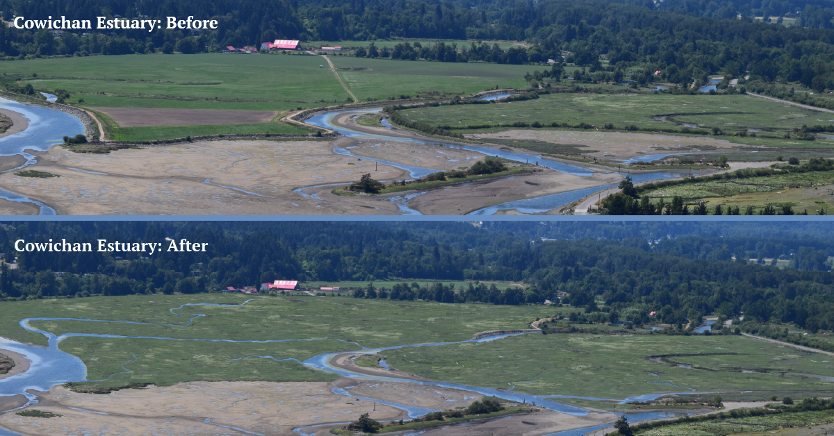
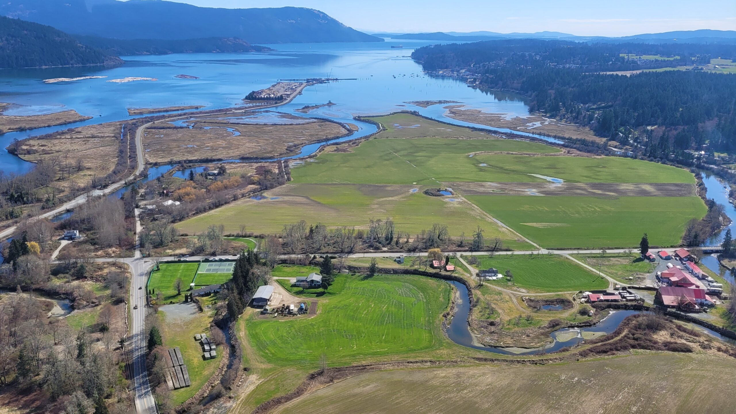
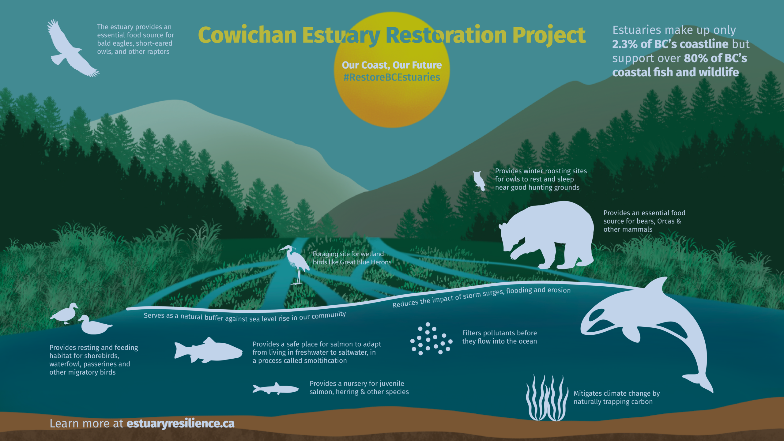
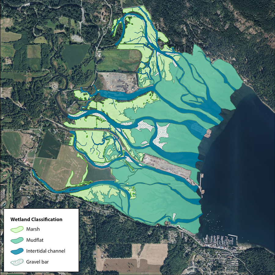
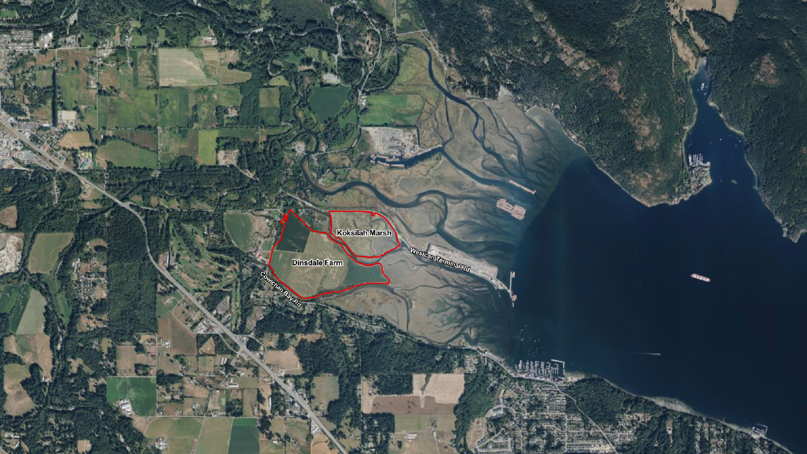
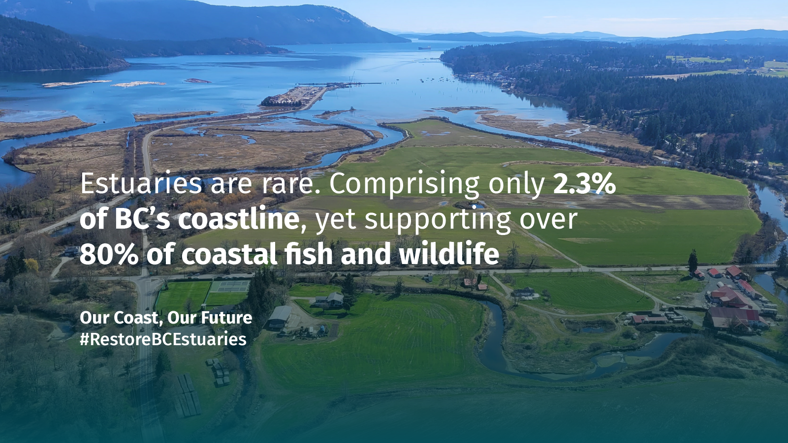
The Cowichan Estuary Restoration Project will revitalize the health of the Cowichan Estuary to conserve biodiversity and protect local communities, now and in the future. Positioned on the traditional territory of the Quw’utsun people (Cowichan Tribes), the Cowichan Estuary Project is the largest estuary restoration project to ever occur on Vancouver Island. The project will restore 70 hectares of marsh habitat and re-establish natural estuarine processes by removing human-made barriers to marsh development and reconnecting freshwater channels to tidally influenced areas. 


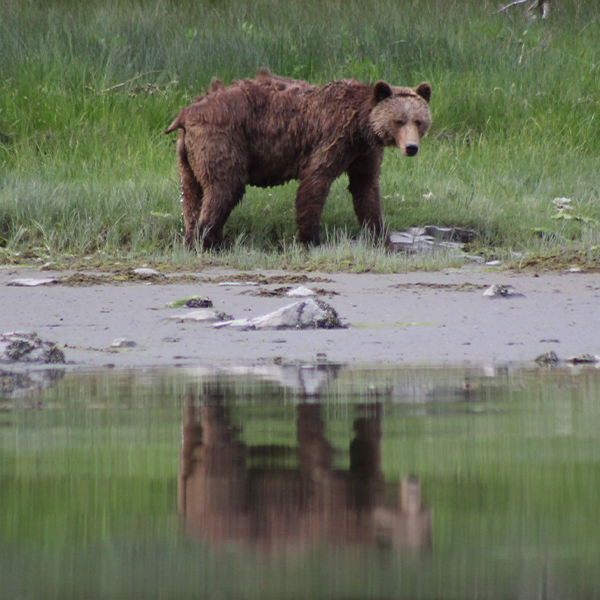
The Cowichan Estuary contains habitats that are critically important for wild Pacific salmon, migratory and breeding birds as well as species at risk. The estuary provides important habitat for up to 230 bird species and thousands of waterfowl can be found in the estuary each winter. This project also places significant emphasis on incorporating Indigenous food systems so that these lands continue to be farmed, providing culturally significant foods and medicine plants to Cowichan Tribes while contributing to the overall food security of the region. 

Importance of the restoration project

The Cowichan Estuary and surrounding region is located near Duncan on southern Vancouver Island, within the traditional territory of the Quw’utsun people (Cowichan Tribes) and is one of the largest and most productive intertidal zones on Vancouver Island.


The estuary is a broad complex of tidal flats and channels, and salt marsh habitat which have been formed by thousands of years of sediment transport and deposition by the Cowichan and Koksilah river systems. 


Since the 1800s, The Cowichan Estuary and surrounding rivers have undergone considerable changes, including river training, diking of valuable marsh habitat, and use by the logging industry for log storage and shipping. In the 1950s, the estuary was bisected by the construction of the Westcan Terminal Causeway, which altered tidal processes, causing the southern half of the estuary to be completely cut off from the Cowichan River. 

In the 1980s, a storm caused a breach in the agricultural dike at Koksilah Marsh which introduced some tidal and riverine processes back into the area.


This project will restore the natural estuary processes to the southern half of the estuary to conserve biodiversity and protect local communities, now and in the future.


Protecting this vitally important estuarine habitat will revitalize the estuary and enable it to support a larger range of fish and wildlife for generations to come, while also advancing local climate resilience against rising sea-levels.

What is an estuary?

An estuary develops where rivers meet the sea and fresh-flowing river water mingles with tidal saltwater to become partly salty or brackish, forming some of the most biologically productive and valuable ecosystems on earth.

Why Estuaries are Critical

  • Estuaries comprise only 2.3% of BC’s coastline but support over 80% of BC’s coastal fish and wildlife, including; Pacific Salmon, Shorebirds, Waterfowl, Short-Eared owls, Grizzly Bears, Bald Eagles, and Orcas.
  • The Cowichan Estuary specifically is rich with biodiversity and provides habitat and breeding grounds for up to 230 bird species.
  • Estuaries provide a sanctuary for juvenile salmonids to feed and mature before they reach the ocean, an essential process for many marine mammals and other wildlife that rely on salmon as a key feedstock.
  • Estuaries provide important natural services like pollutant filtration and storm surge mitigation. Estuaries are also powerful carbon sinks with sediments capable of capturing carbon ten times as quickly as forest soils.

The Restoration Work

The restoration measures for the Cowichan Estuary are informed by an in-depth monitoring program to address the resilience of the Cowichan / Koksilah estuary and the ongoing impacts of the dike and river training that were put in place in the 1800s. The restoration plans were developed by the West Coast Conservation Land Management Program: The Nature Trust of British Columbia, Ducks Unlimited Canada (DUC), Ministry of Water, Land and Resource Stewardship, Ministry of Forests, Fisheries and Oceans Canada, Environment and Climate Change Canada and Habitat Conservation Trust Foundation) and Cowichan Tribes. 

The project’s development has also included a Technical/Scientific Advisory Committee composed of leading nearshore scientists from British Columbia and the United States National Estuary Research Reserve System (NERRS).


The project will involve:

  • The combined removal of over 2 km of dikes at Dinsdale Farm and Koksilah Marsh
  • Creation of intertidal channels and salt marsh habitat
  • Restoration of marine riparian and flood fringe forests
  • Reconnection of areas that have been historically cut off from tidal influence

Timeline

Looking to learn more about the timeline of this project?

Conservation History

Beginning in 1985, The Nature Trust of BC, Ducks Unlimited Canada, and partners in the Pacific Estuary Conservation Program launched a campaign to set aside and restore as much of the Cowichan Estuary landscape as possible. Through a combination of land purchases, donations, and covenants, and with the actions implemented via the Cowichan Estuary Environmental Management Plan, much of the estuary is now protected.

Since 1985, several restoration projects have been completed in the Cowichan / Koksilah Estuary, including projects led by local stewardship groups. Projects have included the restoration of the Doman (now Blackley) Farm marsh, the removal of overhead powerlines at Koksilah Marsh by DUC, two breaches being completed on Westcan Terminal Road, log debris removal from Mariners Island, farm management for migratory birds, eelgrass planting, and invasive species removals.

How to Support

If you’d like to show support, download and post on your social channels. Use the hashtag #RestoreBCEstuaries and tagline ‘Our Coast, Our Future’ to join the conversation.

FAQ

What is the Cowichan Estuary Restoration Project?

Positioned on the traditional territory of the Quw’utsun people (Cowichan Tribes), the Cowichan Estuary Restoration Project aims to restore vitally important fish and wildlife habitat, improve ecosystem function and enhance the resilience of the estuary in the face of a changing climate. The project will rejuvenate habitat crucial for the survival of key fish and wildlife species, including wild Pacific salmon, Dungeness crab, shellfish, migratory and breeding birds as well as various species-at-risk. 


The Cowichan Estuary Restoration Project will restore 70 hectares of salt marsh habitat and re-establish natural estuarine processes by removing human-made barriers to marsh development and reconnecting freshwater channels to tidally influenced areas.

What are the benefits of the Cowichan Estuary Restoration Project?

Estuaries are among the most productive ecosystems on earth. They provide tremendous ecological and environmental benefits. Estuaries only make up 2.3% of B.C.’s coast but support over 80% of all coastal fish and wildlife including Pacific Salmon, Steelhead Shorebirds, Waterfowl, Short-Eared Owls, Grizzly Bears, and Orcas. Economically, 75% of all commercially and culturally important seafood in the Pacific Northwest rely on estuaries including Pacific salmon, clams, oysters, crabs and forage fish, contributing to Indigenous food systems and providing culturally significant foods to Cowichan Tribes while contributing to the overall food security of the region. 


Estuaries are also critically important natural assets for local communities as they provide essential climate services such as flood water absorption and protection from storm surges, as well as being a powerful carbon sink, with sediments capable of capturing carbon ten times as quickly as forest sediments. 


If we do not do this project, 60% of the estuary marsh habitat will be lost. 

This will directly impact the ability of the Cowichan Estuary to continue to provide habitat for fish and wildlife; support the local and coastal economy; and continue to provide the natural environmental services to the Cowichan community.

Who is involved in the Cowichan Estuary Restoration Project?

The Cowichan Estuary Restoration Project is being led by a collective, including The Nature Trust of British Columbia, Ducks Unlimited Canada (DUC), Cowichan Tribes, the Ministry of Water, Land and Resource Stewardship, Ministry of Forests, Fisheries and Oceans Canada, Environment and Climate Change Canada and Habitat Conservation Trust Foundation.


How is the project being funded?

The Cowichan Estuary Restoration Project is funded by the BC Salmon Restoration and Innovation Fund (BC SRIF), a contribution program funded jointly by DFO and the Province of BC, and DFO’s Aquatic Ecosystems Restoration Fund (AERF), as well as project partners.

Why is this restoration work happening?

Estuaries are among the most productive ecosystems on earth. Yet, the climate crisis and human involvement are threatening natural estuary processes putting vital habitat and surrounding communities at risk. Estuaries require a natural balance of freshwater and saltwater to thrive. Without a passage where the river meets the ocean, an estuary cannot complete essential services like pollutant and sediment filtration, flood water absorption, storm surge dissipation, climate change moderation and carbon sequestration. 


In addition to its environmental benefits, many species depend on estuaries to survive. 


Through in depth analysis and monitoring completed by staff and our expert consulting team to assess the resilience of the estuary to sea level rise we established that the Cowichan Estuary will not be resilient to sea level rise and will ‘drown’ or suffer from ‘coastal squeeze’ if this project is not undertaken. If we do not proceed with the restoration project, 60% of the marsh habitat in the estuary will be lost under current scenarios by 2100 and will greatly impact fish, wildlife and the local community. The Cowichan Estuary Restoration project is essential to protect the crucial estuarine ecosystems and surrounding communities in perpetuity. 

Learn more about the science of assessing estuary resilience: https://vimeo.com/519685350/9d9c5e59f8

How long will this restoration work take?

This restoration project is the result of several years of monitoring and assessment of the overall ecological health of the estuary and will be executed over the course of two years.  A key component of this project will be ongoing monitoring and adaptive management of the project site to ensure that we are meeting our restoration goals. This adaptive management may include further works in subsequent years as we monitor how the site evolves over time.

Will there be alternative access to the estuary during the project?

The Cowichan Estuary Restoration Project will revitalize the health of the estuary and improve the recreational experience of those that enjoy nature. This project will restore the thriving ecosystems that the estuary hosts, and can be enjoyed from the alternate access points to the estuary. 


The Maple Grove Park will be closed during the second year of the project but will be reopened upon project completion. While the Dinsdale Farm dike trail will be closed during the second year of the project and will no longer be accessible, people will still be able to enjoy the Maple Grove park for picnics and opportunities for wildlife viewing.


Access to the estuary will still be provided along Westcan Terminal Road where there is a parking area and an interpretive trail.

How will the community be impacted?

The Cowichan Estuary Restoration Project will involve the restoration of over 70 hectares of natural estuarine marshlands and the removal of the dikes and constructing intertidal channels. This will be completed in a staged approach over the course of two years: 

  • Year one (2023): Access may be restricted temporarily, subject to the construction schedule and the need to maintain job site and public safety. The Maple Grove Park will remain open in the first year and access to the Dinsdale Farm dike will be maintained subject to project operational requirements.  
  • Year two (2024): The Dinsdale Farm dike trail will be closed during the second year of the project and will no longer be accessible going forward. Access to the estuary will still be provided along Westcan Terminal Road where there is a parking area and an interpretive trail. Opportunities to provide other trail connections/routes in the conservation area are being explored.


The Cowichan Estuary Restoration Project is an important step towards revitalizing this important ecosystem to conserve biodiversity and protect local communities. The project will improve the estuary’s ability to absorb flood water and storm surge mitigation, benefiting adjacent landowners. A revitalized estuary will restore habitat within the area and allow species, such as salmon, shellfish, orcas, dolphins, herons, bald eagles, and bears, to flourish.

Do the project partners work in partnership with, and support, the agricultural community in British Columbia?

The Nature Trust of BC, Ducks Unlimited Canada (DUC) and our West Coast Conservation Land Management Program partners recognize the incredible importance of the agricultural community in Cowichan and beyond. As of now, we have acquired over 40 conservation areas, tenures, easements (52,887.84 hectares / 124,957.04 acres) that support sustainable agriculture and food production.


Additionally, DUC and its partners support agricultural producers through more than $300,000 in cost-sharing programs across over 4000 acres to support agricultural productivity and economic viability. One example of this is cost sharing of winter cover cropping, which reduces fertilizer costs and soil erosion, while also providing important forage for wintering waterfowl.


On Vancouver Island we continue to work with farmers at several conservation areas throughout Vancouver Island in the Cowichan and Comox Valleys, Black Creek and Oyster River.

Were farmers consulted about this project?

Cowichan Estuary Restoration project partners have consulted with the farm operator situated on the conservation area for several years regarding the ongoing monitoring and the development of the project. The farm operator voluntarily amended the license agreement to enable this project to happen and was, as mutually agreed, compensated accordingly. Timelines of project implementation and phasing were adjusted to allow the farmer operator an additional farming season to transition off the Farm. The Cowichan Estuary Restoration Project is the culmination of years of rigorous research, consultation, and monitoring work which has made it clear to all partners that this project was necessary to ensure the long term resilience and health of the Cowichan Estuary.

Will this project result in flooding of adjacent lands and roadways?

No. The development of this project included in depth and extensive engineering and hydraulic reviews of flood conditions and scenarios utilizing up-to-date modeling, historic records and field observations. The project was reviewed and approved by the Deputy Inspector of Dikes under the Dike Maintenance Act which included an assessment of risk transfer. The project was also presented to the Cowichan Flood Management Working Group. Overall the project will improve flood water conveyance to the estuary from Koksilah River flood waters.

Who owns this land?

It is private property owned by The Nature Trust of British Columbia and Ducks Unlimited Canada and managed by the West Coast Conservation Land Management Program. 

Did the Nature Trust of BC and/or Ducks Unlimited Canada commit to farming this land in perpetuity as part of the acquisition of Dinsdale Farm?

No. A legal review of the acquisition has been undertaken and there are no clauses in the purchase and sale agreements with the Dinsdale Family that state the land was to be farmed in perpetuity.


That being said, the land will continue to produce food and be actively managed as part of the revitalization of Indigenous food systems in the estuary.

Was this land donated or willed to the Nature Trust or Ducks Unlimited by the Dinsdale Family?

No. This land was purchased for the fair market value at the time of the transaction.

Were neighbouring landowners consulted about the change in diking?

Yes. As part of the Provincial Guidelines for Decommissioning a Regulated Dike all impacted landowners (those specifically on Lochmanetz Road) were consulted over several months and provided with detailed assessments of risk transfer for review.

Is this land in the Agricultural Land Reserve (ALR)?

The majority of the land is within the ALR. 11 acres of Dinsdale Farm and 14 acres of Koksilah Marsh are outside of the ALR. To view ALR land designations visit: https://www.alc.gov.bc.ca/alr-maps/


This land will still be used for food production, albeit instead of grain and corn, it will produce salmon, forage fish shellfish, including clams, oysters and crabs, and plant species such as Pacific crab apples, saskatoon berries, wild plums, camas, and Pacific silverweed. This land will remain designated as farmland under the ALR.

Is this land being taken away from the Agricultural Land Reserve (ALR)?

No. There is no exclusion application to remove the land from the ALR.

Is this a permitted use of ALR land?

Yes. In addition to supporting biodiversity and conservation, the land will be used for the revitalization of Indigenous food systems and will continue to support the food security of the area. The project has engaged with the ALC and will be following the guidance provided by the ALC in terms of project components that would be considered a ‘non-farm use’ such as the decommissioning of the section of the dike located within the ALR boundary.

Was this project approved by the Cowichan Estuary Management Committee in accordance with the Management Plan designated under the Environment Management Act?

Yes. This project was reviewed and approved by the committee which includes representatives from the Province of BC, Fisheries and Oceans Canada, Cowichan Tribes, Cowichan Valley Regional District and the Municipality of North Cowichan.

How will this project impact birds in the area?

The Cowichan Estuary Restoration Project aims to restore vitally important fish and wildlife habitat, improve ecosystem function and enhance the resilience of the estuary in the face of a changing climate. The Pacific Birds Habitat Joint Venture has identified 18 priority waterfowl species and associated priority habitat types to support their populations. Of these 18 healthy estuaries are identified as a priority habitat for 16 of these species whereas agricultural lands are identified for 8; noting these 8 species require healthy estuaries as well.


From 2015-2023, our monitoring data has shown that there is higher species diversity and abundance in terms of waterfowl, shorebirds, herons and raptors utilizing the estuarine marsh and intertidal habitat than on the farm fields. By restoring natural estuarine habitat over time we anticipate a greater diversity and abundance of birds will utilize the restored area which includes the majority of priority waterfowl species identified by the Pacific Birds Habitat Joint Venture.

Is there any alternative to this restoration work that doesn’t involve removing the dike?

Filling, draining and diking for conversion to other uses has resulted in 70% loss of the original wetlands in the Fraser River delta and 60% of estuarine marsh habitat in the Salish Sea. Given only 2.3% of BC’s coast is made up of these important ecosystems we cannot afford to lose more.


Monitoring data has determined that the Cowichan Estuary will not be resilient to sea level rise and will ‘drown’ or suffer from ‘coastal squeeze’ if this project is not undertaken. If we do not proceed with the restoration project, 60% of the marsh habitat in the estuary will be lost under current scenarios by 2100 and will greatly impact fish, wildlife and the local community. The Cowichan Estuary Restoration project is essential to protect the crucial estuarine ecosystems and surrounding communities in perpetuity.

Learn more about the science of assessing estuary resilience: https://vimeo.com/519685350/9d9c5e59f8

What is known about water quality and the safety of consuming shellfish from the estuary once converted? Is there a broader plan to re-open the shellfish harvest in Cowichan?

Recreation and commercial harvesting of shellfish is regulated by Fisheries and Oceans Canada with water quality monitoring support/information provided by Environment and Climate Change Canada and the Province of BC. A real time map of open and closed harvesting areas can be found at https://www.dfo-mpo.gc.ca/shellfish-mollusques/cssp-map-eng.htm. The Cowichan Estuary Project aims to restore some of  the natural coastal processes and functions in the estuary by improving the exchange of water and providing a larger area whereby pollutants can be naturally filtered out. It is also anticipated that the restored marsh areas will also result in an increase in the shellfish population which will also benefit water quality as shellfish naturally filter water.

Partners

The Cowichan Estuary Restoration Project is being led by a collective, including Cowichan Tribes, The Nature Trust of British Columbia, Ducks Unlimited Canada (DUC), the Ministry of Water, Land and Resource Stewardship, Ministry of Forests, Fisheries and Oceans Canada, Environment and Climate Change Canada and Habitat Conservation Trust Foundation.


The Cowichan Estuary Restoration Project is funded by the BC Salmon Restoration and Innovation Fund (BC SRIF), a contribution program funded jointly by DFO and the Province of BC, DFO’s Aquatic Ecosystems Restoration Fund (AERF), and Cowichan Tribes through the Aquatic Habitat Restoration Fund (AHRF), and the West Coast Conservation Land Management Program partners, including Fisheries and Oceans Canada, Environment and Climate Change Canada, the Province of BC, Ducks Unlimited Canada, and the Habitat Conservation Trust Foundation.